Mound Street and A Museum of the City of St. Louis

I am writing today to advocate the creation of a Museum of the History of the City of St. Louis where it began, on the bluffs of the Mississippi River. For St. Louis’s place in the broad history of the United States and North America is critical, deep and little celebrated. And this is tragic because to the extent that a people know and appreciate their history they become devoted to shaping its future. This is especially true of children who are a community’s future.

Ancient peoples, who held their bards and other collectors of history in high esteem, realized this but modern societies, in the face of enormous technological advances, are losing their sense of the past and their reverence for the sources of culture at an alarming rate.

This Museum of the City of St. Louis should possess the depth and scholarly weight of the Field Museum of Natural History in Chicago because its focus would not be on St. Louis as a singular urban entity, nor even a single city within the state of Missouri, but on St. Louis as the vortex of an immense area of natural resources and a connecting point to other regions, cultures and markets. It should be so irresistibly interactive that children and adults alike would be drawn into the incredible mystery and drama that history, when it’s well told and illustrated, evokes. They would realize the considerable accomplishments that people like themselves have achieved along the Mississippi, on this stretch of prairie, and be inspired to create and construct the St. Louis of tomorrow. They should also recognize its weaknesses and work to improve them.

You may think this a pie-in-the-sky concept with no chance of succeeding but St. Louisan Bob Cassilly is in fact accomplishing this very thing with the visual arts in his City Museum, fifteen blocks west of the river in downtown St. Louis. Children and adults who venture into that re-imagined ware house experience art on all levels – not simply as viewers, as an audience – but participants in the artistic process – climbing, crawling, sliding and figuring out how to physically negotiate works of art. There are even opportunities for visitors to create their own art while inside. So it can be done. It can be done locally. It can leave not only St. Louisans but people from all over the world – gasping with amazement and becoming themselves – inspired – as does City Museum.

This Museum of the History of the City of St. Louis would begin with that which existing St. Louis museums have neglected – setting a stage for the most significant prehistoric human culture in the Mississippi River Valley – the Mound Builders – then proceed to the first St. Louisans and the Indian trade here, through formation of a state legislature, to a frontier capitol, the golden age of the steamboat, the Civil War, the Great Metropolis of the Mississippi River Valley in 1875, the rise of the modern skyscraper, the largest hosting of human achievements and cultures the world has ever seen in the Louisiana Purchase Exposition of 1904 and finally to vision-shaping the future.

St. Louis’s present – and only – commemorations of the Mound Builders who raised the greatest capital north of Mexico to the east in present day Cahokia, Illinois and extended it westward to include this side of the Mississippi River – are a one block stretch called Mound Street – that is difficult to find because it is so short that you miss it while driving if you blink – and a granite boulder on Broadway, south of Mound Street, at Howard Street, from which the memorial identification plate has long since disappeared.

A great city preserves and commemorates its past to inspire its future. It’s time for St. Louis to become a great city again.

© 2010 Maureen O’Connor Kavanaugh

Update: I’m very happy to report that as of 2018 the City of St. Louis finally has a museum on the riverfront to match the brilliance of the Gateway Arch, which rises above it; a museum that places the city in the national context it deserves. And it’s even better than I dreamed it would be! Visitors can enter it from the park just east of the Old Courthouse.

While there I heartily recommend that you explore the marvelously re-envisioned and landscaped Gateway Arch National Park, in which the museum is located. Treasures – books, historic replicas, toys and more – can be found in the museum gift shop.   

Posted in Art & Architecture, Commentary and Criticism, History, St. Louis | Tagged , , | 2 Comments

Hidden History of Downtown St. Louis

I’m excited to announce that the Hidden History of Downtown St. Louis which I began a year ago for the History Press & Arcadia Publishing has arrived locally at Barnes and Noble Book Stores, The Book House in Maplewood, the Campbell House Museum downtown and is also available online at both barnesandnoble.com (http://www.barnesandnoble.com/w/hidden-history-of-downtown-st-louis-maureen-kavanaugh/1124493060?ean=9781467136839) and amazon.com (https://www.amazon.com/Hidden-History-Downtown-St-Louis/dp/1467136832/ref=sr_1_1?s=books&ie=UTF8&qid=1485382411&sr=1-1&keywords=hidden+history+of+downtown+st.+louis).

9781467136839-1This quality paperback is a compilation of the research which has gone into the walking tours and coach tours that I give of downtown St. Louis along with some 60 vintage images and contemporary photographs, mostly the work of my husband, Tom Kavanaugh. But the book contains far more detail than a walking tour allows for.

It begins with the Mississippian Mound Era (approximately the year 1000) and culminates in the present day. If you’ve been following my blog from an island in the Pacific, from Alaska, Europe or the British Isles it’s unlikely you’ll be taking a walking tour with me any time soon.

I love giving site-oriented walking tours and personally taking visitors back to the 18th, 19th and 20th centuries but this Hidden History of Downtown St. Louis will allow you to join me virtually from the comfort of your own home.

I will be doing my first book signing this coming Saturday, January 28th at The Book House in Maplewood, Missouri from 2:00 – 4:00 in the afternoon. If you can join me there I’d love to sign a book for you! If you’ve already bought the book online or at Barnes and Noble locally feel free to bring it along Saturday and I’ll be happy to sign it.

I won’t be telling ghost stories as I did the last time I appeared at The Book House. I don’t believe their new location is as charmingly haunted as the original Book House in Rock Hill was but I’m anxious to find out whether their little ghost moved along with their amazing inventory of books!

Posted in Art & Architecture, Books, Civil War, Downtown St. Louis, Happenings, Neighborhoods | 2 Comments

New Wing of the Field House Museum in Downtown St. Louis Brims with Stories

This gallery contains 16 photos.

The oldest house downtown has a fresh new face and a brand-new wing that provides rich context for St. Louis as she emerged as “Queen of the West” and the tumultuous years leading up to and during the Civil War … Continue reading

More Galleries | Tagged , , | Leave a comment

Update from St. Lou

Dear Readers,

I’m sorry to have been absent for so long a time. But life happens and other kinds of writing have demanded my attention. I will soon begin blogging again on a regular basis but I’m focused  presently on a book for Tht.e History Press’s Hidden History Series on Downtown St. Louis (https://www.arcadiapublishing.com/Navigation/Series/THPSeries/HIDDEN-HISTORY).

20151119_084100 - Version 2

It will contain many of the stories that I tell on my walking tours but with a lot more detail than touring time usually allows for.

220px-Pierre_Chouteau_JrThere will also be new stories about St. Louis people and events that are little known or virtually unknown to the general public and I’m very excited to be telling them!

In the meantime I’ve also been giving tours, most recently a Valentine Sweet Tooth Coach Tour for a wonderful group of Seniors from the Rockwood Bank in High Ridge, Missouri.

It began with Chocolate Covered Strawberries from Merbs Candies and the calories just kept adding up at La Patisserie Chouquette, Rigazzis and The Missouri Baking Company on The Hill, and finally Bissingers Chocolates.

20160211_091751

I’ve also been constructing new tours for spring and summer. So while absent from Word Press, I’ve been very busy. Thanks for not giving up on me!

Be back soon.

Illustration Credit: Pierre Chouteau, Jr. – in the public domain at wikimediacommons.org.

Photos: Maureen Kavanaugh, author of this blog.

Posted in Books, Commentary and Criticism, History, St. Louis | 2 Comments

Navigating St. Louis

800px-SaintLouisMetroLinkEadsBridge

I was born a walker. For me the most sensuous way to experience a place – whether it be Dublin or Paris or St. Louis – is to walk it; following scents, letting the colors of a place seep into me, pausing here and there to taste, or stopping dead in my tracks to follow the lines of a structure upward, past balconies and French doors, over mountainous gables, along rooftop gardens, wrought-iron widow walks, gargoyles or sphynxes. Some perspectives just cannot be gleaned unless you’re standing still.

20150728_152149

The people I guide on my walking tours, especially those from other parts of the U.S. and the world, are astonished by how much intrigue and beauty St. Louis holds. Many of these treasures are easily missed unless you’re on foot.

20150825_153547

But walking’s not for everyone, and not all of the time. It’s possible to explore St. Louis via coach, carriage ride as well as running tours.

There’s nothing quite like the wind in your face and hair as you glide through favorite neighborhoods or ride the topography of an uncharted territory for the first time on a bike.

20150727_163959Now that bike racks have been situated in so many St. Louis neighborhoods you can enjoy the double pleasures of biking to and from a place, then hopping off and parking to explore it at your leisure on foot – an autumn farmer’s market in Tower Grove Park, the shops in old-new-town Kirkwood, or the specialty markets of The Hill, catching snippets of conversation in different languages and the various accents and energies that distinguish a neighborhood.

Cycling has re-emerged in recent years as a healthy and very popular way of navigating St. Louis and its environs, as it has in many other parts of the U.S. and the world.

800px-Cyclists_at_Hyde_Park_corner_roundabout_in_LondonAnd with local, state and federal initiatives paving the way for clearly defined bike lanes, cycling is becoming safer than it has been since automobiles took to the roads in great numbers in the early 20th century.

20150727_135909

Avid cyclists like Jeremy Bradshaw who sells bikes and bike equipment at Urban Shark (http://bigshark.com/about/urban-shark-pg778.htm), a full-service bike shop at 1009 Locust Street in downtown St. Louis welcomes the bright, white bike lanes that the City of St. Louis has added to the downtown streetscape and hopes they will facilitate safe travel on congested roads, as they link to many, already-established bike lanes in other areas of St. Louis City and County.

20150727_153724

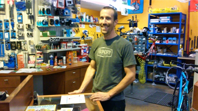
Urban Shark stands adjacent to St. Louis’ Downtown Bicycle Station, an initiative of Trail Net (trailnet.org/) that provides 20-hour access, over 120 bike racks, showers and a locker room to cyclists commuting to and from work on their own steam.

Archaeological evidence suggests that the first humans to enter North America by Berengia from Asia did so on foot, in successive migrations between about 30,000 and 11,000 years ago.

Beringia_land_bridge-noaagov

It also reveals that humans have walked all over the globe. As more and more lower levels of culture are unearthed, the extents to which hunter-gatherers and their descendants followed the herds they hunted are expanding.

1024px-American_bison_k5680-1The first known “Native Americans” arrived in what is today Missouri about 12,000 years ago following elk, deer, and bison herds from the New Mexico area, where the climate had become very hot, dry and the vegetation scarce.*

The earliest man-made trail west of the Mississippi became known from the 17th century as the Great Osage Trail, taking its name from the Osage nation, the  Ni-u-kon-ska (People of the Middle Waters) who dominated this area.**

1845_trailmap

Long before the Osages, by about the year 900, Mississippian Mound Builders were traversing the Mississippi, the master river of North America, and its tributaries in canoes.

They built a capital in what is today the Greater St. Louis area – roughly between Cahokia, Illinois and St. Louis, Missouri, an area rich with fertile soil on the river’s east bank and honeycombed with caves on its west, and were trading with other tribal Americans as far north as the Great Lakes, as far south as the Gulf of Mexico, as far east as the Appalachian Mountains and as far west as the Rocky Mountains.

1024px-Fer_-_Le_Canada,_ou_Nouvelle_France,_la_Floride,_la_Virginie,_Pensilvanie,_Caroline

Early humans around the world crossed bodies of water in simple crafts long before history records. What we know as canoes today (and pirogues in parts of the Mississippi River Valley in the 18th century and lower Louisiana today) are so ancient and universal a form of transportation their origins are as yet and may never be, definable.

1024px-Charles_Deas_-_The_Trapper_and_his_Family

Everything in the St. Louis we know today began with the river, the great Mississippi, which the Aninshinaabe (Ojibwe/Algonquin) people called Misi-ziibi and the French rendered as Mesipi.

1024px-St_Louis_Birdseye_Map_1896

Soon after Pierre Laclede established Post de Saint Louis as an Indian center of commerce in the mid-Mississippi River Valley, tribal delegates from as far west as the Great Plains and the Rocky Mountain came here to trade. Beginning as a tiny, international port linking New Orleans in the south with Montreal in the north, and European markets with Native American trade, the Mississippi allowed Port St. Louis to grow exponentially.

George_Caleb_Bingham_-_Jolly_Flatboatmen_in_Port

Flatboats and keel boats became preferred forms of transportation for the trappers and traders plying the Mississippi and Missouri rivers with large quantities of goods – European imports and American furs and hides.

1024px-Traveling-by-flatboat-engraving-by-Alfred-R-Waud

After Lewis and Clark returned to St. Louis with a mapped route to the Pacific Ocean in 1806 and the United States government began offering free land out the Oregon Trail, settlers arrived in the thousands, overland in covered wagons and on the rivers by boats, to get permission for that land, making St. Louis the Gateway to the West. The Oregon Trail in St. Louis began at Broadway and Market Street (the first road in St. Louis).

When the Mississippi froze in winter, covered wagons could cross it without being ferried, to make their way west from St. Louis.

Crossing_the_Mississippi_on_the_Ice_by_C.C.A._Christensen

Ground was broken in St. Louis in 1851 for the Pacific Railroad/later the Missouri Pacific slated to run from St. Louis via the state capital of Jefferson City to the western boundary of Missouri, and onward to the Pacific Ocean.

1024px-Missouri_Pacific_Number_152_(MSA)_(9933287425)

Prior to James Eads engineering the first primarily steel bridge in the world connecting Missouri with Illinois in downtown St. Louis, train cars had to be ferried across the Mississippi.

1024px-Eads_Bridge_St_Louis_1874_ppmsca08973u

Chartered in 1851, the St. Louis-Iron Mountain Railroad carried granite from southern Missouri north, for the cobblestones on the St. Louis levee and granite for the piers Eads sunk to bedrock for his ground-breaking bridge at St. Louis.

iron_mountain_railIt would also transport hundreds of Confederate POWs from Pilot Knob, MO to prison in St. Louis during the Civil War.

While St. Louis reigned as the great metropolis of the mid-Mississippi River Valley steamboats of varying sizes and designs reigned the river’s mighty waters transporting thousands of passengers, millions of tons of cargo and sometimes horrific diseases like cholera.

The_Levee_or_Landing,_St._Louis,_Missouri

The Golden Age of the Steamboat vanished as it began in the 19th century. Elegant ships, like those once piloted by Mark Twain have long-since given way to the more functional barges and tugboats that line the lengthy Port of St. Louis today; a port where Sam Clemens remembered the steamboats sometimes docked “a mile long and three deep” along the levee.***

800px-Riverboats_at_Memphis

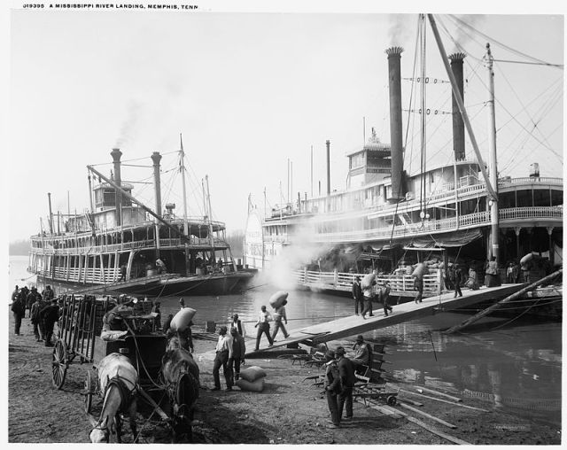
These barges carry regional, natural resources such as grain and coal to gulf ports where they’re loaded for shipping to destinations as distant as Africa and Asia. We remain an international port.

James Eads designed the St. Louis Bridge in 1874 to carry not only horses, carriages, wagon loads and pedestrian foot traffic but full-scale trains, allowing them to cross the Mississippi River from Illinois to Missouri (and back) at full throttle. He linked its west platform to a tunnel he engineered for underground travel until the train emerged into what became one of the largest switching yards in the U.S. (previously Chouteau’s Pond).

800px-Union_Station_St_Louis_diagram

The vast majority of trains entering and leaving St. Louis no longer pull into the rail yard behind Union Station (now a hotel complex) by-passing it for the Amtrak  Station four blocks east.

20150730_143314

At the Civic Center Station travelers can conveniently switch from Amtrak to MetroLink Light Rail Service – or buses – to continue their journey on to wherever they’ll be staying. MetroLink Transit has five stops in downtown St. Louis (two of which, 8th & Pine and Convention Center, are located in the tunnel) and links to university campuses, hospitals, shopping centers, and Lambert International Airport. MetroLink Transit also serves Illinois passengers in the East St. Louis area.

20150727_134623

Since bicycles are allowed on trains, riders can use light rail to cover large distances on the way to areas they want to bike and back.

Interstate highways like the Daniel Boone and Mark Twain expressways have replaced the trails forged by Native American tribes but our rivers remain natural highways for commerce as well as pleasure.

1024px-Gemini_spacecraftNavigating what became St. Louis hasn’t changed entirely over the last several thousand years except perhaps in the area of flight with McDonnell-Douglas, later Boeing, pioneering aircraft and spacecraft in ways ancient Americans never dreamed.

The past quarter-century has seen a renewed appreciation for the natural environment which has so shaped and nourished the culture of the St. Louis area.

1024px-ChainOfRocksBridge_StLouisMO

Strides are being made in the creation of riverfront trails for biking, walking and running, and for the preservation of marshes, creeks, and wildlife areas but the struggle to maintain the critical balance between nature and the human imprint upon it is ongoing. We have a lot of catching up to do.

This coming weekend, on Sunday, September 20th Trailnet of St. Louis (founded in 1988 to promote the St. Louis Riverfront Trail) is hosting a Share the Street Party (http://trailnet.org/calendar/trailnets-2015-share-the-street-party/) from 11:00am – 7pm, in Old Post Office Plaza downtown with food and craft beers, artist demonstrations representing St. Louis’ many diverse neighborhoods, and live entertainment by the St. Louis Blues Society. If you come you’ll have an opportunity to discover great area cycling opportunities and initiatives in and around St. Louis on a crisp, autumnal day!

IMG_20140330_142420

Special thanks to Jeremy Bradshaw of Urban Shark and Carol Schmidt & Marcia Quint of Trailnet for taking the time for an interview!

References: *”Early Man in North America: The Known to the Unknown” by Valerie Ann Polino – http://www.yale.edu; **Under Three Flags by Maureen Hoessle, Virginia Publisjing, 2005; ***Life on the Mississippi by Mark Twain, James R. Osgood & Co. Boston, MA. 1883 and Chatto & Windus, London, England, 1883.

Soulard 025Photo Credits: SaintLouisMetroLinkEadsBridge.jpg – author William Rosmos, his own work, copyrighted & shared CC BY-SA 3.0 at wikimedia commons.org; Cyclists at Hyde Park corner roundabout in London.jpg – author Gerry Lynch, his own work, copyrighted & shared CC BY-SA 3.0 at wikimediacommons.org; American Bison, Missouri Pacific Number 152, Riverboats at Memphis, Chain of Rocks Bridge St. Louis, and Gemini Spacecraft – all in the public domain at wikimediacommons.org; Townhouse at 13th & Lami Streets in Soulard & Lenore K. Sullivan Blvd. at the Foot of Washington Avenue (above) – Tom Kavanaugh, Sr. All other photos by Maureen Kavanaugh, author of this blog.

Illustration Credits: All maps &  illustrations are in the public domain at wikimediacommons.org including The Trapper and His Family by Charles Deas, The Jolly Flat Boatmen by Thomas Hart Benton, Crossing the Mississippi on the Ice by Carl Christensen, and the Traveling by Flatboat engraving by Alfred R. Waud.

Posted in Commentary and Criticism, Downtown St. Louis, Happenings, Neighborhoods, St. Louis | Tagged , , , , , , , , , , , , | 3 Comments

Washington, D.C. 150 Years After the Civil War

11709459_10205460530610421_7751577229929032699_n

If Abraham Lincoln does indeed walk at midnight, the byways of Springfield, Illinois as the poet Vachel Lindsay suggested in 1914, he surely walks the streets of the nation’s capitol where he knew such troubled dreams. For Lincoln, one of the most brilliant politicians in American history, knew well the fatal consequences of political disputes in this republic.

A Harvest of Death. Gettysburg, July 1863. Timothy O'Sullivan. (War Dept.) Exact Date Shot Unknown NARA FILE #: 165-SB-36 WAR & CONFLICT BOOK #:  253

A Harvest of Death. Gettysburg, July 1863. Timothy O’Sullivan. (War Dept.)
Exact Date Shot Unknown
NARA FILE #: 165-SB-36
WAR & CONFLICT BOOK #: 253

He grew to manhood in an era when such arguments routinely ended in gunfights at dawn (or later) and walked battlefields (Bull Run, Sharpsburg, Fredericksburg, Petersburg and Antietam) where the blood-drenched crops of war left almost no room for a man to set his feet on solid ground.

LincolnatgettysburgLincoln spoke eloquently of his concerns at Gettysburg when he resolved “that government of the people, by the people, for the people shall not perish from the earth,” describing that battlefield as testing “whether this nation or any nation so conceived and so dedicated can long endure.” Yet 150 years after he urged his fellow countrymen and women to “finish the work we are in, to bind up the nation’s wounds,” some wounds are yet to heal and many politicians divisively open new ones to further their agendas; something which tragically is neither new to human history nor unique to the U.S.

Washington has changed in ways that Lincoln could not have imagined but he would still find familiar places within walking distance of the White House, in great part due to his legacy. The exterior of the people’s house is little changed since the photograph below was taken in the 1860s.

1860s_White_House

Blair House, which he visited for consultations with editor, Frank Blair still stands out the back door and just across Lafayette Park. Although Blair and his son Montgomery, who Lincoln appointed Postmaster General of the United States are long gone, the latter buried in St. Louis’ Bellefontaine Cemetery, not far from the grave site of Edward Bates, the president’s first Attorney General; both men serving in President Lincoln’s fractious Cabinet.

1024px-Blair_House_daylight

The Custis-Lee Mansion continues to overlook the White House from a rise across the Potomac River but the number of graves has vastly risen since Civil War dead began to buried beneath Robert E. and Mary Custis Lee’s elegant lawn. And the number of foreign wars that followed the War Between the States would surely give Lincoln pause.

1024px-Arlington_House

Ford’s Theater, where Lincoln enjoyed brief respites from the burdens of politics and war remains a mere six block walk from the White House, barely far enough for President Lincoln to stretch his long legs.

20150706_152922Daylight finds an unending stream of visitors to the Peterson House across the road where Lincoln breathed his last, never opening his eyes to see the interior.

2015 marks the 150th anniversary of not only the end of the deadliest man-made disaster in the history of the United States but of the assassination of Abraham Lincoln.

Although the city of his death bears George Washington’s name it is Lincoln who looms over it larger than life. Perhaps because what began so idealistically yet imperfectly with Washington could have ended so disastrously here with Lincoln. Yet didn’t.

20150707_122102

One cannot miss the slender elegance of  President Washington’s Monument but it’s the Lincoln Memorial that every American feels he or she must visit. And once visited it’s never forgotten. Daniel Chester French sculpted the arduous, exhaustive struggles for justice and peace so splendidly in Abraham Lincoln’s visage. His sculpture is both a revelation and a challenge. It represents what at best it means to be an American and it suggests that the work may be endless.

800px-Lincoln_Memorial

If a spectral Abe Lincoln does restlessly walk the streets of Washington, I hope that he sometimes pauses for pleasure to wander the Smithsonian’s Air and Space Museum, or Museum of Natural History, or the National Gallery of Art, for they are worlds of wonder and beauty unto themselves with the power to inspire one’s hope for humanity.

20150709_134953

20150709_145758

Washington, D.C. is in 2015 a large and bustling American city, far more densely populated and cosmopolitan than the Washington of Lincoln’s day, where Pennsylvania and Maryland avenues were still dirt roads.

PennsylvaniaAvenue_DC_1860 It’s made up of miles and miles of row houses and sprawling suburbs of almost every description; a world capitol where much of the world comes to parlay and negotiate, and where immigrants from many nations have made their home and diversified the culture.

20150709_124027(1)

But in ways that are both suitable and haunting the Civil War and our nation’s wisest statesman seem ever-present here, reminding us how critical civil discourse is to the preservation of this republic for which so much has been sacrificed.

References: wikipedia.com; http://www.blairhouse.org; http://www.arlingtoncemetery.mil.

20150706_154107Illustration: Pennsylvania Avenue, DC – 1860 – in the public domain at wikimediacommons.org.

Photo Credits: A Harvest of Death, Gettysburg 1863 – Timothy H. O’Sullivan, President Abraham Lincoln at Gettysburg, Close-up of  The Lincoln Memorial, South Entrance of The White House in the 1860s and Arlington National Cemetery – all in the public domain at wikimediacommons.org.

20150709_123754Blair House daylight.jpeg. – author: Ben Schumin, 2006 at wikimediacommons.org – Creative Commons Attribution Share Alike -2.5 License; Exterior of Ford’s Theater, The Presidential Box in Ford’s Theater, The Peterson House in Washington, D.C. and Long-Shot of the Lincoln Memorial – Tom Kavanaugh, Sr.; Robert Gould Shaw Memorial by Augustus Saint- Gaudens, Alexander (Sandy) Calder Mobile in the West Building of the National Gallery of Art, Entrance to China Town in Washington, D.C. and Starbucks Coffee China Town, Washington, D.C. – Maureen Kavanaugh, author of this blog.

Posted in DC 150 Years After the Civil War | Tagged , , , , , , , , | Leave a comment

Christmas in St. Louis 1764 – 2014

New Year’s Eve 2014, the 7th Day of Christmas. Exterior work continues steadily on the Basilica of Saint Louis, King of France, the oldest man-made structure on the downtown riverfront, and in the crypt and museum area underground. But the interior body of the basilica was beautifully completed in time for this, the 250th celebration of Christmas since our founding.

20141230_094104

Evergreen trees and poinsettias fill the sanctuary which stood in stark simplicity throughout the Advent season, dominated by Charles Quest’s monumental reproduction of Diego Velasquez’ Cristo Crucificado. 

The crosses that hung from the vertical posts of the first two Churches of Saint Louis on this site, would have been far smaller, much like that in Holy Family Log Church in Cahokia, Illinois.

IMAG0086 The first of these churches was a very simple structure raised in 1770. The second, erected in 1776 was modeled more closely on Holy Family Log Church in scale and quality, with a fine Norman truss, stuccoed walls between the vertical posts, and mullioned windows lit by the rising sun. They faced the Mississippi on La Rue de l’Eglise (Church Street).

IMAG0093

In December of 1764 La Poste de Saint Louis, Laclede’s fur trading post was not quite a year old. The closest church, Holy Family (pictured above) stood roughly six miles southeast of the bluffs on which Laclede and his stepson, Auguste Chouteau laid out and built the village, across the waters of the Mississippi River, made treacherous by ice.

IMAG0144With neither a church nor a resident priest, St. Louis’ earliest celebrations took place in the homes of the settlers. They centered around a treasured Christmas Creche (Manger Scene) where prayers were said, and before which the children placed their shoes in anticipation of finding them filled with treats when they awoke on Christmas morning.

800px-julaftonen_av_carl_larsson_1904_2Following Midnight Mass a beautiful supper was served with special foods that had been in preparation for days, then a day of great festivity ensued with many visits – house to house – among friends and family members.

Everyday clothes were set aside as St. Louisans put on their finery, the silks and satins and laces saved for special occasions.

When the first churches were built and Masses said, homilies were given in French and then an Indian dialect.

800px-twelfth0011

Christmas night ushered in the first of the nightly balls that led up to Epiphany/Three Kings Day and 12th Night. Epiphany (which the Irish called Little Christmas) was a day of gift-giving in the tradition of the Three Kings/The Magi who brought gifts of gold, frankincense, and myrrh to the Christ Child in Bethlehem. In much of the Christian world it did (and still does) mark the official end to Christmastide. King Cakes were baked with little trinkets inside and the last of the carols sung.

1024px-Greuze-gâteau_des_rois French carols – Pat-a-Pan, Les Anges dans Nos Campagnes (Angels We Have Heard on High) and in time the lovely Huron Carol composed by French Jesuit missionary, St. Jean de Brebeuf, Canada’s oldest Christmas song. For there were far more French Canadians in Colonial St. Louis than there were native French.

640px-Three_chiefs_of_the_Huron

After arriving in Canada Fr. Jean de Brebeuf, S.J. lived and worked among the Huron people in whose native language he composed the carol. He was later captured by Iroquois warriors and ritually martyred.

Written in Wyandot, the Huron Carol was later translated into French and English.

‘Twas in the moon of winter-time
When all the birds had fled,
That mighty Gitchi Manitou
Sent angel choirs instead;
Before their light the stars grew dim,
And wandering hunters heard the hymn:
“Jesus your King is born, Jesus is born,
In excelsis gloria.”

Within a lodge of broken bark
The tender Babe was found,
A ragged robe of rabbit skin
Enwrapp’d His beauty round;
But as the hunter braves drew nigh,
The angel song rang loud and high…
“Jesus your King is born, Jesus is born,
In excelsis gloria.”

The earliest moon of wintertime
Is not so round and fair
As was the ring of glory
On the helpless infant there.
The chiefs from far before him knelt
With gifts of fox and beaver pelt.
Jesus your King is born, Jesus is born,
In excelsis gloria.

O children of the forest free,
O sons of Manitou,
The Holy Child of earth and heaven
Is born today for you.
Come kneel before the radiant Boy
Who brings you beauty, peace and joy.
“Jesus your King is born, Jesus is born,
In excelsis gloria.”

Unlike the personal manger scenes that St. Louisans had in their homes, the Christmas Creche in the Basilica of Saint Louis is nearly life-size, the figures cast in iron by the P. Serf Company of New York and shipped to St. Louis in time for Midnight Mass in 1866.

The priest offering Mass, Fr. Egidius Smulders, CSSR “appealed to those present to contribute to paying for the Nativity Scene, as an expression of their gratitude for loved ones having returned home from the Civil War, or simply as a gesture of their gratefulness for an end to the bitter fighting that had torn our nation apart.”*

20141230_090208

According to the sign at the creche “the better part of the $800 needed to pay for the crib scene” was collected that Christmas Day. By the Civil War Era the carols being sung in St. Louis included Spanish, English, German, and many other languages along with African-American Spirituals like “Go Tell It on the Mountain.”

20141230_091322

A tremendous restoration/renovation of St. Louis’ Old Cathedral has been underway for many months. It will continue for many more. But if you visit during the last of the Twelve Days of Christmas and any time after, you will find beautiful surprises. Especially if you are a native St. Louisan! From color palette to artwork it’s quite a transformation back into the 19th century.

In addition to the painting of the Coronation of Saint Louis of France, a gift from one of his descendants, Louis XVIII of France to Bishop Louis DuBourg, four other paintings now hang in the basilica.

20141230_094025

Situated on the only piece of land in St. Louis that has never been bought or sold, the Basilica of Saint Louis stands within the original church block mapped out by city founder Pierre Laclede in the winter of 1764; the only piece of Colonial St. Louis in the downtown area still being used for its original purpose. However the present church stands in the upper left corner of the church block illustrated below and it faces south not east and the Mississippi. It remains as it was always intended to be – a place of refuge,

First_Catholic_church_in_St_Louis_Missouri

peace and reverence – central to and apart from, the world around it. Firstchristmascard-1 20140918_115526

References: *Poster description of The Christmas Creche in the Basilica of Saint Louis, King of France.

Illustrations: All illustrations used above – Julaftone, Twelfth Night Merry Making in Farmer Shakeshaft’s Barn, Greuze Gateau, Adoration of the Magi, Three Chiefs of the Huron,  First Catholic Church in St. Louis, and The First Christmas Card – are in the public domain at wikipedia.com.

Photo credits: all photos inside and outside the Basilica of Saint Louis, King of France were taken by Maureen Kavanaugh, author of this blog, with my cell phone.

Posted in Uncategorized | 1 Comment

Richmond Heights, MO: Commemorating History

Thursday evening, November 6, 2014 the Richmond Heights Historical Society, under the direction of their Vice President, Joellen Gamp McDonald, will host a speakers event commemorating the 250th Anniversary of the Founding of St. Louis that highlights the work of six local historians. I am honored to be one of them.

Most of the presenters – Frederick Fausz, Andrew Weil, Elizabeth Terry and Esley Hamilton are professional historians – while Doug Houser and I are historians by avocation. But we are all of us storytellers and preservationists of one sort or another, from architecturally significant structures to first-hand accounts of individuals who have shaped the history of Greater St. Louis.

During 2013 I had the pleasure of conducting two, five-hour coach tours and three, half-day walking tours of the City of Richmond Heights, an inner-ring suburb of the City of St. Louis as part of their Centennial Celebration. These guided tours were the culmination of three years of research that had at its core Joellen Gamp McDonald’s and Ruth Nicholls Keenoy’s wonderful book, Images of America: Richmond Heights 1868-1940.

One of the most fascinating aspects of that research was interviewing scores of Richmond Heights residents and business owners from all walks of life and documenting their recollections of different eras. These included Arianna Aughey, who lives with her husband John and their children in the oldest house in Richmond Heights, a farmhouse built by Jean Baptiste Bruno in about 1890.

Jean Bruno and his wife Victorine Verrier came to the United States as children with French parents (well outside the Colonial period) and raised thirteen children of their own on a farm he purchased after returning to St. Louis County from the Gold Rush. The Bruno family prospered and became well-known for their extensive orchards. Their home stands on what was the last parcel of farmland in the City of Richmond Heights.

Legend has it that a young Lt. Robert E. Lee remarked upon the similarities between the topography of St. Louis and the topography of his native Richmond, Virginia when he was supervising a project on the Mississippi River with the Army Corps of Engineers in the late 1830s suggesting the name Richmond Heights for a hilly area west of the city boundary.

In 1901 the John W. Ranken Realty Company was the first to advertise a subdivision they called Richmond Heights in the Globe Democrat Newspaper. There were certainly enough Virginia transplants in the St. Louis area (beginning with the great William Clark in 1806) for Lee’s suggestion to have spread and endured long enough to inspire the name of a subdivision, tho’ that’s unprovable and the connection may be happenstance.

The most distinctive 19th century landmark in what became Richmond Heights was the Edward and Lavinia Gay Mansion pictured on page 15 of Richmond Heights: 1868-1940, an elegant, Italianate Villa situated at the highest point of a hilly, forested estate. Begun in 1857 the Gay Villa wasn’t completed until just after the Civil War. As late as 1935 when that property was being developed into two luxurious subdivisions, Lake Forest and Hampton Park, “as many as 1200 trees were still standing on what had been the Gay Estate, 900 of which had trunks measuring a foot or more in diameter.”**

Today Richmond Heights’ century-plus trees and Deer Creek (which runs through Hampton Park) are the only surviving remnants of the community’s 19th century roots. The Grove Mansion at 1108 Hillside Drive exemplifies the demeanor of the homes built on the former Gay Estate during the 20th century. The Mediterranean-style Grove Mansion, designed by Louis LaBeaume in 1911 for Edwin Wiley Grove, Jr., heir to his father’s chemicals fortune, is one of the most stunning homes in St. Louis County.

But the split-level Modernist home designed by Harris Armstrong for Dr. and Mrs. Henry J. Hampton holds a greater historical significance as the boyhood of Henry Hampton Jr., who documented the Civil Rights Struggle for African-Americans in his Pulitzer-Prize Winning, Eyes on the Prize.

I would like to thank very specially Joellen Gamp McDonald, archivist and Vice-President of the Richmond Heights Historical Society for inviting me to construct and guide the walking tours and coach tours celebrating the centennial of the city’s founding and for her invaluable assistance in creating those tours. It was an honor and a privilege to work with Joellen and the many, many wonderful residents and business people who shared with me their memories of the City of Richmond Heights!

Posted in Uncategorized | Leave a comment

The Shaw Art Fair: Neighborhood Crucible for Creativity

20141005_135517 There will be very little history in this blog post which is instead a celebration of the arts as supported and engendered by a St. Louis neighborhood which has its origin in a British immigrant with an eye for beauty and the soul of a botanist . . . 640px-1909_-_Henry_Shaw_-_portrait_in_nightcap_-_MoBOT_GPN_1982-0180 . . . and the work of 135-something artists who exhibited this past weekend at the Shaw Art Fair along the park in Flora Place, directly east of The Missouri Botanical Garden. 20141005_135904 Henry Shaw, for whom the neighborhood is named, arrived in St. Louis in 1818, at the age of eighteen, seizing the opportunity to expand the family steel business back in Sheffield, England. For what he found when he stepped off the steamship Maid of Orleans and onto the St. Louis Levee was a flourishing inland river port brimming with prospective customers – residents as well as thousands of pioneers headed west. 1024px-Ruins_of_Sheffield_Manor_1819_1 He set up shop on Main Street, offering essentials such as flour and sugar along with some of the finest steel cutlery in the world and made himself a fortune. Strolling the town at his leisure (St. Louis wouldn’t be incorporated as a city until December of 1822) Shaw became intrigued with the remarkable garden of Dr. Antoine Saugrain. Lemonnier_-_Antoine-François_de_FourcroyEducated in Paris as a physician and chemist under Antoine Fourcroy (depicted on the left), Saugrain grew numerous medicinal herbs that he introduced to St. Louis, along with others native to the Mississippi River Valley. Henry Shaw would be inspired by Saugrain to create a botanical garden of his own and to endow medical research related to botany at Washington University in St. Louis. The Shaw Neighborhood website includes cartographer Camille Dry’s rendering of Henry Shaw’s (extensive) Garden in 1875 (http://www.shawstlouis.org/all-about-shaw/history/). 1024px-Shaw_house_tg If you click on the above link you will see that Shaw’s country estate was a part of and  surrounded by prairie, specifically the Prairie des Noyers which had been platted in St. Louis’ French Colonial Period. Part of that estate (which Shaw purchased in 1840) is known today as Tower Grove Park and the rest as The Missouri Botanical Garden. IMG_20121024_110906 An astute businessman, Shaw invested in elegant residential developments adjacent to his estate that spawned what is today much of the Shaw Neighborhood. 20141005_135400 The Shaw Neighborhood Improvement Association (SNIA) launched its now famous art fair in 1993, making this their 21st annual event. 20141005_134047 On two perfect autumn days in the first weekend of October 2014, thousands strolled Flora Place to view a wide spectrum of art, many to take some of it home with them. 20141005_135618 In addition to the exhibit spaces an area was set aside for young people to create art. 20141005_131209 And student artists from neighborhood schools like The Grand Center Arts Academy, a charter school founded in 2010 in the former Carter Carburetor Complex, 20141005_131449 and St. Margaret of Scotland School were on hand to talk about their exhibited art work, 20141005_131257 and proudly point it out to family members and friends. Providing children with the opportunity to view their work in the context of professional artists – of jewelers, painters, printmakers, sculptors, and photographers who have devoted their lives to a daring and precarious profession can be inspiring. 20141005_132551 As is being able to watch an artist like Robert Powell work on a mahogany carving. Founder of The Portfolio Gallery and Education Center (http://www.portfoliogallerystl.org/) at 3514 Delmar Blvd. in the Grand Arts Center, Powell is a former industrial arts instructor who’s devoted the past twenty-five years to providing a showcase for African-American artists and “putting art in daily conversation.” 20141005_132916 There were artists from Michigan – Latvian artist, Marina Terauds, who produces her elegantly, whimsical prints using traditional methods faithfully preserved for more than four hundred years in her homeland (http://www.marinaterauds.com/) 20141005_130022 –  and Wisconsin, sculptor Thomas Wargin (http://www.wargin.com/index_bio.php) whose fascinating marriage of man and machine took 1st Place in the Fine Arts Category – 20141005_134451 – alongside St. Louis artists like Jay Thompson of Kirkwood, whose hilarious and marvelously rendered Cat Works (http://thompson-catworks.com/) brought smiles and laughter from viewers. 20141005_134806 20141005_132259

What a wonderful, autumnal, neighborhood event this is!

References: shawstlouis.org website and wikipedia. org.

Illustration Credits: Ruin of Sheffield Manor and Antoine Fourcroy – in the public domain at wikimedia.org.

Photography Credits: Henry Shaw at 85 and Henry Shaw’s Tower Grove House – in the public domain at wikimedia.org; Family Sculpture in The Missouri Botanical Garden – Maureen Kavanaugh. All other photos used with the kind permission of Thomas Kavanaugh, Sr.

Posted in Art & Architecture, Happenings, Neighborhoods, Shaw Neighborhood, St. Louis | Tagged , , , , | Leave a comment

Re-Visiting History: The Battle of Pilot Knob, Missouri

PilotKnob24

At the invitation of good friends who live in Farmington, my husband and I took a scenic drive this past weekend out of St. Louis, over the Ozark Plateau and into the beautiful Arcadia Valley to attend a 150th Anniversary Re-Enactment of the Civil War Battle of Pilot Knob, Missouri/ aka The Battle of Fort Davidson (http://missouricivilwar.net/fort-davidson/index.htm).

IMG_20110616_143539It’s difficult to get a sense of the Civil War Era in St. Louis outside of specific landmarks – the Chatillon-DeMenil Mansion, The Campbell House and Eugene Field House Museums, the Ulysses S. Grant National Historic Site at White Haven or The Old Courthouse (pictured at the left), where in some respects time stands still. St. Louis has changed so greatly since that time.

We were eager to view this re-eanactment on the actual battle field where it took place, which is preserved by the State of Missouri as The Fort Davidson Historic Site, in a mountainous area little changed since 1864.

20140927_134733

Every third year The Battle of Pilot Knob is staged where Confederate and Union soldiers lie buried in a common grave, in what had been the fort’s long rifle pit.

20140927_142659

Fort Davidson is a hexagonal earthwork constructed by the Union  Army three hundred yards from the base of Pilot Knob Mountain,* adjacent to what was during the Civil War the southern terminus of the Iron Mountain Railroad; its purposes to protect the rail line and defend the City of St. Louis from attack by the Confederate Army.

Pilot Knob is part of the Saint Francois Mountain Range in southeast Missouri, which takes its name from the river originating in the mountains. Granite from these mountains was used in the manufacture of cobblestones on the St. Louis Levee and the piers James Eads sunk to bedrock when he constructed the first bridge across the Mississippi at St. Louis; granite shipped from Iron County on board the Iron Mountain Railroad.**

800px-Knob_lick_view-26aug06

Although Pilot Knob, Missouri is located eighty miles south of St. Louis, incidents in both places related to the Civil War, impacted the other greatly.

601px-St-louis-riot1Chief among these were an event that took place in St. Louis in May of 1861 that inflamed thousands of rural Missourians to enlist in the Army of the Confederacy, and Maj. Gen. Sterling Price’s failure in September of 1864 to capture arms and ammunition from Fort Davidson at Pilot Knob, which would have enabled him to lay siege to St. Louis with an army of 12,000.

When the Civil War broke out in 1861 St. Louis was the only city in the State of Missouri.

The Federal Arsenal of the West, which produced an enormous amount of ammunition was located here on the west bank of the Mississippi River. After the war Ulysses Grant wrote that had the Federal Arsenal at St. Louis fallen to secessionists in the spring of 1861 the Union could not have won the war.

Nathaniel_Lyon_on_horseback_1General Nathaniel Lyon, a Connecticut native and graduate of the U.S. Military Academy at West Point, is the Union officer credited with preventing that from happening. Two monuments dedicated to him stand in Lyon Park, immediately west of the St. Louis Arsenal grounds in St. Louis.

The riot that broke out as the Federal troops ordered by Lyon to surround the Missouri Militia at Camp Jackson, resulted in the wounding and killing of not only soldiers but many civilians including children.

The Camp Jackson Affair was sensationalized by newspapers around the nation as The Massacre at Lindell’s Grove, fueling enlistment in the Confederate Army.

Wilsons-cropped-better

Nathaniel Lyon was killed in the first major battle of the Civil War in Missouri, the Battle of Wilson’s Creek, on August 10, 1861 precisely three months to the day since the incident at Camp Jackson.

Map_of_Pilot_Knob,_Mo.,_and_Vicinity._Wm._Hoelcke,_Captn._&_Addl._A._de_C._-_NARA_-_305779

There remains to this day, a haunting sense in the mountainous areas of southern Missouri, where a Trail of Tears was forged by thousands of the Cherokee Nation in 1830.

tent-life

And where thousands of American soldiers and Missouri residents lost their lives during the guerrilla warfare that racked this part of the state between 1861 and 1864.

71D1+HjD47LPaulette Jiles’ novel, Enemy Women, is one of the most lyrically powerful tellings of the Civil War in Missouri that I’ve ever read.

Her story takes place between Doniphan County (a little south of Pilot Knob) and the City of St. Louis, where main character, Adair Colley is imprisoned for months with other women refugees from various parts of Missouri.

As shocking as this was to me while reading the novel, more shocking still was confirmation that women were indeed imprisoned at Gratiot Street and later in what became known as the Chestnut Street Womens Prison.

Watching the battle re-enactment at Pilot Knob and observing re-enactors (some who live in the area and many others from around the U.S.) walking to and fro in period dress, chatting over campfires or interpreting history from numerous stations like that of the Women’s Aid is a moving experience.

20140927_134634 - Version 2

Such historic re-enactments are curious and important events. There is something surreal and unforgettable about having the past and present flow concurrently around you, as you sit on a plastic chair capturing a 19th century battle scene with a camera or cell phone.

PilotKnob05

Events that dramatically shape history like the Civil War, the deadliest man-made disaster in the history of this nation, should never be forgotten. Lest they be repeated.

civil-war-hospital

Whatever it is that inspires individuals (over 1,400 in this event) to re-enact history as a spectacle for others to experience, engage in and learn from, is truly marvelous.

PilotKnob25

PilotKnob21

Over this two-day Re-Enactment of the Battle of Pilot Knob (http://battleofpilotknob.org/reenactment.html) spectators were estimated to exceed 40,000 in number. Twenty-five thousand saw the Saturday event alone.****

20140927_134315

PilotKnob20

Confederate Maj. Gen. Sterling Price’s plot to seize weapons and ammunition from the Federals at Fort Davidson in southeast Missouri failed.

20140927_142155Although his army of 12,000 won a victory over the 1,450 Federal troops stationed there under the command of Gen. Thomas Ewing, Jr., it was a hollow one. All but twenty-eight of Ewing’s force escaped, the last blowing up the Powder Magazine on their way out, while a thousand of Price’s troops were killed or wounded.

Price left Missouri for the final time during the Civil War after his army’s defeat in the Battle of Westport (today Kansas City) on October 23, 1864. There 30,000 men engaged in the largest battle fought west of the Mississipppi River with the Union Army carrying the day. Maj. Gen. Sterling Price is buried in Bellefontaine Cemetery, St. Louis.

799px-Westport-cropped

Special thanks to Tiffany and Allan, Christian and Cameron Smith, for their warm and generous hospitality, and for luring us to the Arcadia Valley for this momentous event.

20140927_143331

References: *http://mostateparks.com/page/54963/general-information, gleaned from The Missouri Department of Natural Resources; **http://en.wikipedia.org/wiki/St._Francois_Mountains#wikipedia, U.S. Geological Survey,*** Enemy Women by Paulette Jiles, William Morrow Publisher, an Imprint of Harper Collins, 2002; ****Sept. 13, 20014 article by Tim O’Neil in the St. Louis Post- Dispatch: http://www.stltoday.com/news/local/metro/events-recall-th-anniversary-of-last-major-civil-war-battles/article_bedde314-c634-5f9f-b694-ddb95434bde1.html.

Illustration Credits: Book Illustration of Union General Nathaniel Lyon, St. Louis Riot at Lindell’s Grove/Camp Jackson in St. LouisThe Battle of Wilson’s Creek Mural and The Battle of Westport Mural – from the State Capital Building of Missouri, and 1863 Map of Pilot Knob, MO and Vicinity – all in the public domain at wikimedia.org. Cell phone captures of the Diagram of Fort Davidson in the Missouri State Park Museum at Pilot Knob, and Exhibit Depicting Maj. Gen. Sterling Price – Maureen Kavanaugh.

PilotKnob03 - Version 2

Photo Credits: Rotunda of The Old Courthouse at St. Louis Hung with Replica of the U.S. Flag Flying Over the Courthouse When the Civil War Broke Out in 1861 – used with the kind permission of John Powel Walsh; View towards the Saint Francois Mountains of the Missouri Ozarks from the top of Knob Lick Mountain -“Knob lick view-26aug06” by Wikipedian Kbh3rd – Own work. Licensed under Creative Commons Attribution-Share Alike 3.0 via Wikimedia Commons – http://commons.wikimedia.org/wiki/File:Knob_lick_view-26aug06.jpg#mediaviewer/File:Knob_lick_view-26aug06.jpg.;two vintage black & white images: Civil War Hospital and Camp Life – in the public domain – Shmoop Editorial Team, “The Civil War,” Shmoop University, Inc. , 11 November 2008, http://www.shmoop.com/civil-war/ (accessed October 1, 2014).

PilotKnob12Above contemporary photos (excepting those taken with my cell phone) – the 4th, 8th and 10th – by Maureen Kavanaugh, author of this blog.

All other photos generously taken and shared by Thomas Kavanaugh, Sr.

Posted in American Civil War, Books, Civil War, Civil War St. Louis, Happenings, History, Missouri in the Civil War | Tagged , , , , , , , , , , | Leave a comment